Caribbean Birding Trail

Know the Caribbean, Bird by Bird

Donate
  • About the CBT
    • Interpretive Guide Training
  • Countries
    • Countries A-I
      • Anguilla
        • Cove Pond
        • Dog Island
        • East End Pond
        • Forest Bay Pond
        • Katouche Canyon
        • Long Pond
        • Meads Bay Pond
        • Merrywing Pond System
        • Prickly Pear Cays
        • Road Salt Pond
        • Scrub Island
        • Sombrero
        • West End By-the-Sea Ponds
        • West End Pond
      • Antigua and Barbuda
        • Bethesda Dam
        • Christian Valley
        • Codrington Lagoon
        • McKinnon’s Salt Pond
        • Two Foot Bay National Park
      • Aruba
        • Spaans Lagoon
      • Bahamas
        • Abaco
        • Andros
        • Cat Island
        • Crooked Island and Acklins
        • Eleuthera
        • Exumas
        • Grand Bahama
        • Great Inagua
        • Long Island
        • Mayaguana
        • New Providence
        • San Salvador
      • Barbados
      • Bonaire
        • Dos Pos IBA
        • Gotomeer
      • British Virgin Islands
        • Josiahs Bay Salt Pond
        • Sandy Cay
      • Cuba
        • Guanahacabibes
        • Humboldt National Park
        • Mensura-Piloto National Park
        • Viñales
        • Zapata Swamp
      • Curaçao
        • Christoffel National Park
        • Salt Pans of Jan Thiel
      • Dominica
      • Dominican Republic
        • Central Mountain Range
          • Constanza and Valle Nuevo
          • Ebano Verde Reserve
          • Hatillo
          • Jarabacoa with Armando Bermúdez and José del Carmen Ramírez National Parks
          • La Joya de San Francisco
          • Loma Quita Espuela
          • Pico Diego de Ocampo, Santiago
        • Southeast
          • Bávaro
          • Cumayasa
          • Del Este National Park
            • Del Este National Park: Boca de Yuma
            • Del Este National Park: Guaraguao
            • Del Este National Park: Padre Nuestro Trail
            • Del Este National Park: Saona Island
          • Ecological Foundation Trail, Punta Cana
          • Limón Lagoon
          • Los Haitises National Park
            • Los Haitises National Park: Caño Hondo
            • Los Haitises National Park: Los Limones
          • Monte Plata
        • Southwest
          • Aguacate and Zapotén
          • Cabo Rojo and Pedernales
          • Cabral Lagoon
          • Cachote, Eastern Bahoruco
          • Jimaní
          • Lake Enriquillo
          • Loma Charco Azul
          • Oviedo Lagoon, Jaragua National Park
          • Puerto Alejandro and Tortuguero
          • Rabo de Gato and Puerto Escondido
          • Sierra de Bahoruco National Park
            • Los Arroyos, Sierra de Bahoruco National Park
        • North Coast
          • Cayos Siete Hermanos
          • El Choco National Park, Cabarete
          • El Limón, Samaná
          • Estero Hondo
          • Loma Guaconejo
          • Loma Isabel de Torres, Puerto Plata
          • Monte Cristi and Saladilla
          • Nalga de Maco National Park, Río Limpio
          • Samaná
        • Around Santo Domingo
          • Las Salinas de Baní
          • Mirador del Norte Park
          • National Botanical Garden
          • Ozama Wetlands
      • Grenada
        • Antoine Lake
        • Beausejour/Grenville Vale
        • Diamond Rock
        • Grand Etang National Park
        • Levera National Park
        • Mt. Hartman National Park
        • Telescope Pond
        • Woburn Bay MPA
      • Guadeloupe
        • Mountain Road
        • Pointe des Chateaux
    • Countries J-Z
      • Jamaica
        • Ahhh…Ras Natango Gallery and Garden
        • Barbecue Bottom Road
        • Black River Great Morass
        • Cockpit Country
        • Ecclesdown Road
        • Flagstaff
        • Green Hills Field Station
        • Hardwar Gap
        • Hope Gardens
        • Portland Bight Protected Area
        • Stewart Town
      • Martinique
        • Rocher du Diamant
      • Montserrat
      • Puerto Rico
        • Camuy Coastal Area
        • Culebra National Wildlife Refuge
        • Laguna Cartagena National Wildlife Refuge
      • Sint Eustatius
        • Pilot Hill
        • Quill/Boven National Park
        • Zeelandia Beach
      • St. Lucia
      • Sint Maarten
        • Great Salt Pond
        • Little Bay Pond
      • St. Martin
        • Amuseum Naturalis at The Old House
        • Étang Cimetière de Grand Case
        • Étang de la Barrière
        • Pic Paradis
      • St. Vincent and the Grenadines
        • Grenadines
          • Bird Sanctuary
          • Mustique Lagoon
          • Mustique Ponds Walk
        • Saint Vincent
          • Richmond Beach
      • Trinidad and Tobago
        • Tobago
          • Kilgwyn Swamp
          • Little Tobago
        • Trinidad
          • Asa Wright Nature Centre
          • Brasso Seco Paria Village
      • Turks and Caicos
        • Grand Turk
        • Middle Caicos
        • North Caicos
        • Providenciales
        • Salt Cay
        • South Caicos
  • Tours
  • Guides
  • Get Involved
  • Contact Us

You are here: Home / Anguilla / Sombrero

Sombrero

  • About Sombrero
  • The Birds
  • Tour Operators and Guides

Sombrero IBA located about 40 miles north of Anguilla is approximately 94 acres in size. Rising up from the water and lacking a single beachhead, access is via a ladder up the cliff line.

Rich in history, it was once the site of phosphate or “guano” mining and is the location of the lighthouse that marks the shipping lane between the Atlantic Ocean and Caribbean Sea known as the Anegada Passage.

Guano Mining Ruins on Sombrero (Photo by Jacqueline A. Cestero)

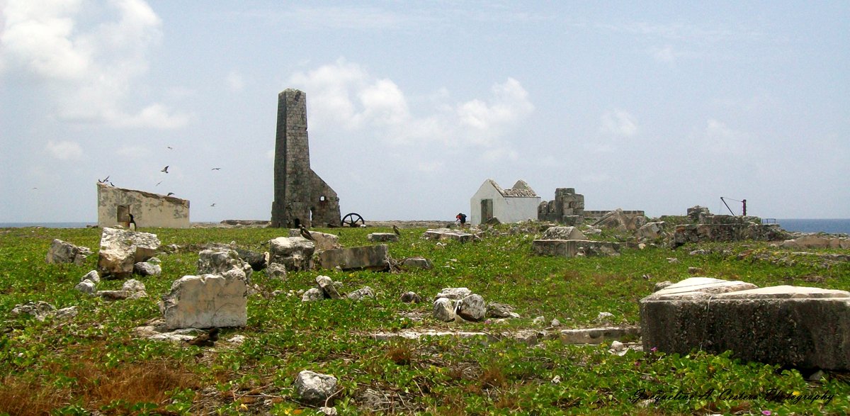
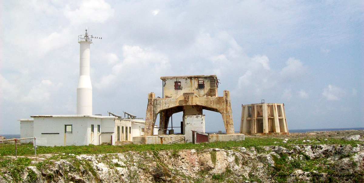
On January 1, 1868, the first light glowed from the Sombrero Lighthouse. The lighthouse was manned until 2002 when the structure was replaced by an automated tower. Today, remnants of the mining operation as well as the living quarters of the Lighthouse Keepers, remain as a reminder of the island’s storied past.

Contrast of Old & New Automated Lighthouse on Sombrero (Photo by Jacqueline A. Cestero)

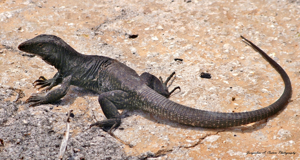
In 2018 after tireless work by the Anguilla National Trust, Sombrero was designated as Anguilla’s first RAMSAR site in an effort to protect the island’s colorful history, seabird populations and endemic reptiles.

Sombrero Landscape (Photo by Jacqueline A. Cestero)
Sombrero Cliffs (Photo by Jacqueline A. Cestero)

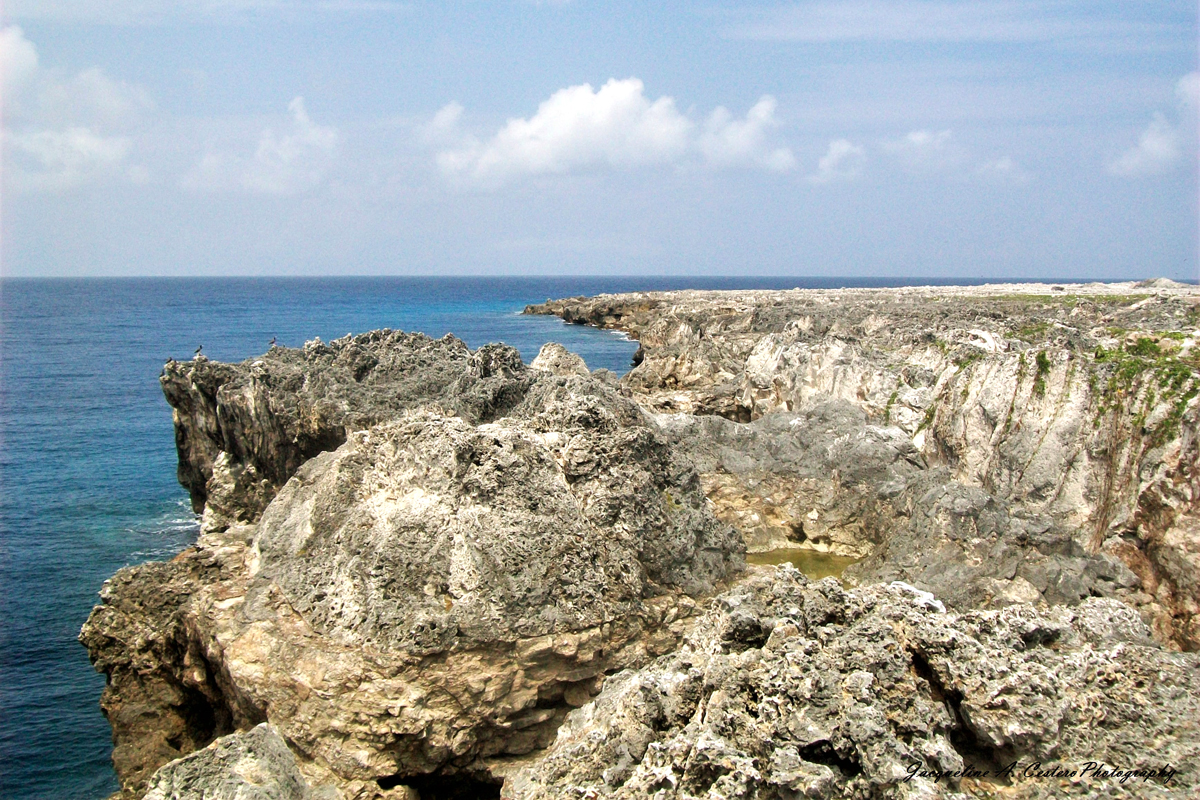
The stark landscape devoid of most vegetation except for low scrub, is covered with seabird nests. The endemic Sombrero Ground Lizard can be seen on the ground in search of food.

Endemic Sombrero Ground Lizard (Photo by Jacqueline A. Cestero)

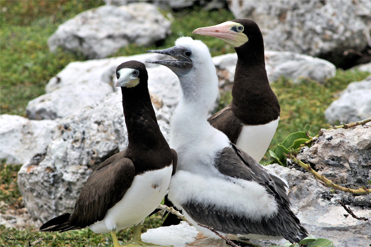
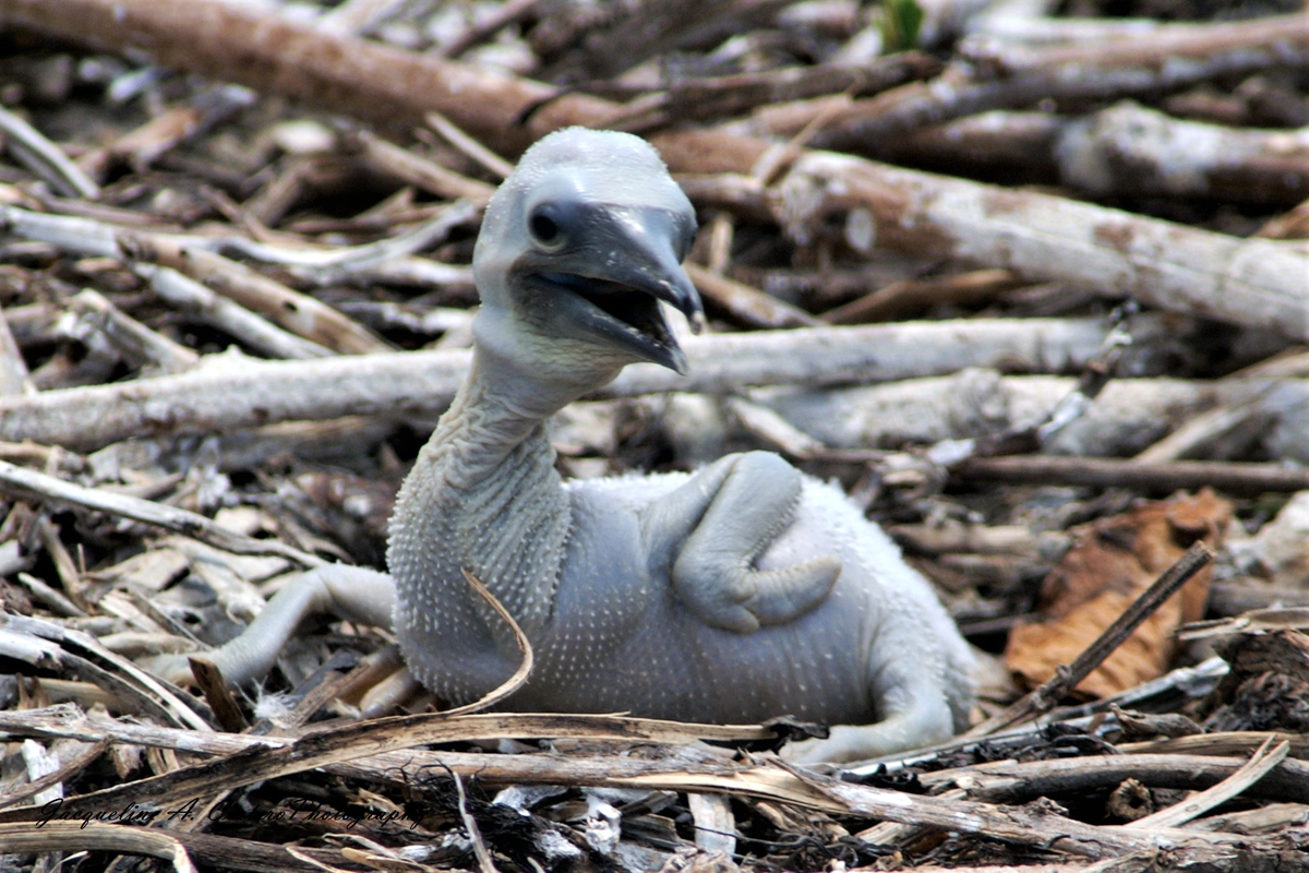
It is reported that 14 species of seabird once nested on Sombrero. Today Bridled Terns nest in numbers that merit global significance. The Brown Booby and Brown Noddy nest here with regional significance. Masked Boobies are also present and breed in large numbers.

Brown Booby Parents with Molting Chick (Photo by Jacqueline A. Cestero)
Brown Booby Chick (Photo by Jacqueline A. Cestero)

The island is surrounded by a marine park where tuna, Mahi Mahi and other marine life abound.

Nature Explorers Anguilla offers tours to this site!

Sombrero

Anguilla Sites

  • Cove Pond
  • Dog Island
  • East End Pond
  • Forest Bay Pond
  • Katouche Canyon
  • Long Pond
  • Meads Bay Pond
  • Merrywing Pond System
  • Prickly Pear Cays
  • Road Salt Pond
  • Scrub Island
  • Sombrero
  • West End By-the-Sea Ponds
  • West End Pond

Anguilla Partners

  • Anguilla National Trust


Anguilla Tour Operators

  • Nature Explorers Anguilla

Recommended Bird Guides

A Guide to the Birds of Anguilla by Steve H. Holliday, Karim V. D. Hodge, and Damien E. Hughes

Birds of the West Indies by Herbert Raffaele, James Wiley, Orlando Garrido, Allan Keith, and Janis Raffaele

Birds of the Lesser Antilles by Ryan Chenery


Want to know how you can be involved?

Do you know of a place that should be part of the Caribbean Birding Trail? Are you the owner of a lodge or hotel and want to attract eco-tourists? Are you a guide interested in the birdwatching market? Then, get involved with our project!

Get Involved

The Latest from BirdsCaribbean.org

Twitter
Birds Caribbean
Birds Caribbean
@BirdsCaribbean

It was an extraordinary #GlobalBigDay2023 for the Caribbean! 🎉 We recorded an increase 📈 in the no. of #birders participating in #GBD & #birds recorded 👏🏽Head on over to our blog for a more info! bit.ly/GlobalBigDayR… #GlobalBigDayBirdsCarib @Birdlifejamaica @grupojaragua pic.twitter.com/nl1U…

reply retweet favorite
4:15 pm · June 2, 2023
Twitter
Emma Lewis
Emma Lewis
@Petchary

In the Caribbean, World Parrot Day strives to raise awareness about the many threatened endemic species · Global Voices Thank you ⁦@JanineMFranco⁩ 🦜🦜🦜 #WorldParrotDay globalvoices.org/202…

reply retweet favorite
2:26 am · June 2, 2023 ·
Retweeted by Birds Caribbean
Twitter
Audubon Society
Audubon Society
@audubonsociety

Wondering what's going on with our on-cam Osprey pair, Skiff and Dory, as they continue to incubate their three eggs? Get the latest by tuning in anytime via @exploreorg: bit.ly/3FRLQup pic.twitter.com/GNps…

reply retweet favorite
2:26 am · June 2, 2023 ·
Retweeted by Birds Caribbean
Twitter
Carol Gordon
Carol Gordon
@carolpopegordon

Now that it's really hot here I went out early with my camera instead of lolling around with my coffee and posting on Twitter. Despite the lack of caffeine I found this Northern Cardinal enjoying the mulberry tree just down the bike path behind my house. #birdingwithouthcaffeine pic.twitter.com/GjtG…

reply retweet favorite
2:25 am · June 2, 2023 ·
Retweeted by Birds Caribbean
Twitter
Sharon Ní Bhaoill
Sharon Ní Bhaoill
@goddessmode

Black-crowned Night-Heron foraging along Gerritsen Creek in Marine Park today. pic.twitter.com/AcPu…

reply retweet favorite
2:25 am · June 2, 2023 ·
Retweeted by Birds Caribbean

Our Site

  • Home
  • About the CBT
  • Countries
  • Tours
  • Guides
  • Get Involved
  • Contact

Search

Follow

Sign up for our Mailing List

Copyright © 2011–2023 Caribbean Birding Trail. A project of BirdsCaribbean.