Caribbean Birding Trail

Know the Caribbean, Bird by Bird

Donate
  • About the CBT
    • Interpretive Guide Training
  • Countries
    • Countries A-I
      • Anguilla
        • Cove Pond
        • Dog Island
        • East End Pond
        • Forest Bay Pond
        • Katouche Canyon
        • Long Pond
        • Meads Bay Pond
        • Merrywing Pond System
        • Prickly Pear Cays
        • Road Salt Pond
        • Scrub Island
        • Sombrero
        • West End By-the-Sea Ponds
        • West End Pond
      • Antigua and Barbuda
        • Bethesda Dam
        • Christian Valley
        • Codrington Lagoon
        • McKinnon’s Salt Pond
        • Two Foot Bay National Park
      • Aruba
        • Spaans Lagoon
      • Bahamas
        • Abaco
        • Andros
        • Cat Island
        • Crooked Island and Acklins
        • Eleuthera
        • Exumas
        • Grand Bahama
        • Great Inagua
        • Long Island
        • Mayaguana
        • New Providence
        • San Salvador
      • Barbados
      • Bonaire
        • Dos Pos IBA
        • Gotomeer
      • British Virgin Islands
        • Josiahs Bay Salt Pond
        • Sandy Cay
      • Cuba
        • Guanahacabibes
        • Humboldt National Park
        • Mensura-Piloto National Park
        • Viñales
        • Zapata Swamp
      • Curaçao
        • Christoffel National Park
        • Salt Pans of Jan Thiel
      • Dominica
      • Dominican Republic
        • Central Mountain Range
          • Constanza and Valle Nuevo
          • Ebano Verde Reserve
          • Hatillo
          • Jarabacoa with Armando Bermúdez and José del Carmen Ramírez National Parks
          • La Joya de San Francisco
          • Loma Quita Espuela
          • Pico Diego de Ocampo, Santiago
        • Southeast
          • Bávaro
          • Cumayasa
          • Del Este National Park
            • Del Este National Park: Boca de Yuma
            • Del Este National Park: Guaraguao
            • Del Este National Park: Padre Nuestro Trail
            • Del Este National Park: Saona Island
          • Ecological Foundation Trail, Punta Cana
          • Limón Lagoon
          • Los Haitises National Park
            • Los Haitises National Park: Caño Hondo
            • Los Haitises National Park: Los Limones
          • Monte Plata
        • Southwest
          • Aguacate and Zapotén
          • Cabo Rojo and Pedernales
          • Cabral Lagoon
          • Cachote, Eastern Bahoruco
          • Jimaní
          • Lake Enriquillo
          • Loma Charco Azul
          • Oviedo Lagoon, Jaragua National Park
          • Puerto Alejandro and Tortuguero
          • Rabo de Gato and Puerto Escondido
          • Sierra de Bahoruco National Park
            • Los Arroyos, Sierra de Bahoruco National Park
        • North Coast
          • Cayos Siete Hermanos
          • El Choco National Park, Cabarete
          • El Limón, Samaná
          • Estero Hondo
          • Loma Guaconejo
          • Loma Isabel de Torres, Puerto Plata
          • Monte Cristi and Saladilla
          • Nalga de Maco National Park, Río Limpio
          • Samaná
        • Around Santo Domingo
          • Las Salinas de Baní
          • Mirador del Norte Park
          • National Botanical Garden
          • Ozama Wetlands
      • Grenada
        • Antoine Lake
        • Beausejour/Grenville Vale
        • Diamond Rock
        • Grand Etang National Park
        • Levera National Park
        • Mt. Hartman National Park
        • Telescope Pond
        • Woburn Bay MPA
      • Guadeloupe
        • Mountain Road
        • Pointe des Chateaux
    • Countries J-Z
      • Jamaica
        • Ahhh…Ras Natango Gallery and Garden
        • Barbecue Bottom Road
        • Black River Great Morass
        • Cockpit Country
        • Ecclesdown Road
        • Flagstaff
        • Green Hills Field Station
        • Hardwar Gap
        • Hope Gardens
        • Portland Bight Protected Area
        • Stewart Town
      • Martinique
        • Rocher du Diamant
      • Montserrat
      • Puerto Rico
        • Camuy Coastal Area
        • Culebra National Wildlife Refuge
        • Laguna Cartagena National Wildlife Refuge
      • Sint Eustatius
        • Pilot Hill
        • Quill/Boven National Park
        • Zeelandia Beach
      • St. Lucia
      • Sint Maarten
        • Great Salt Pond
        • Little Bay Pond
      • St. Martin
        • Amuseum Naturalis at The Old House
        • Étang Cimetière de Grand Case
        • Étang de la Barrière
        • Pic Paradis
      • St. Vincent and the Grenadines
        • Grenadines
          • Bird Sanctuary
          • Mustique Lagoon
          • Mustique Ponds Walk
        • Saint Vincent
          • Richmond Beach
      • Trinidad and Tobago
        • Tobago
          • Kilgwyn Swamp
          • Little Tobago
        • Trinidad
          • Asa Wright Nature Centre
          • Brasso Seco Paria Village
      • Turks and Caicos
        • Grand Turk
        • Middle Caicos
        • North Caicos
        • Providenciales
        • Salt Cay
        • South Caicos
  • Tours
  • Guides
  • Get Involved
  • Contact Us

You are here: Home / Dominican Republic / Around Santo Domingo / Las Salinas de Baní

Las Salinas de Baní

  • About Las Salinas de Baní
  • The Birds
  • How to Get There

Salinas de Baní is located on the peninsula of Las Calderas approximately 60 km (37.3 miles) or about a 1.5-hour drive west of Santo Domingo. A large hyper-saline pond – Salado del Muerto – used for salt extraction, is the main attraction for birds, but the area is also characterized by extensive sand dunes, inter-dunal swales, thickets, mangroves, lagoons, mudflats, and both sandy and rocky beaches.

Birding Areas

Bahía las Calderas (Map by Dana Gardner)


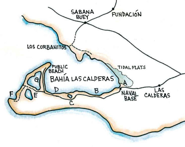
Point A. Start looking for birds on the mud flats on your right just after passing the usually unmanned first guard post. Proceed several yards further where there is a second post that is frequently occupied. Stop and ask the guard where to park, and ask permission to look for birds. This can be a very good place for shorebirds and waders.

Point B. After passing the naval base, continue another 2 km (1.2 miles). Look on your right where you will see less extensive sand and a sandbar in the bay. Here there are some unmarked trails through the dunes to the water’s edge where shorebirds are sometimes found. Look across the bay where flamingos may be seen at the edge of the mangroves.

Point C. After passing some houses, about 0.5 km (0.3 miles) further on you will once again see mud flats and mangroves on your right. Stop here and follow an unmarked foot trail though the thorn trees where you will reach a small bay surrounded by mangroves. This small pool can be a good place for over-wintering warblers, including Blackpoll Warbler, Prairie Warbler, and Northern Waterthrush. It is also good for the permanent resident subspecies of the Yellow Warbler. You should also closely scan the mangroves at the edge for Clapper Rail.

Point D. Another 0.5 km (0.3 miles) further, the road will cross a culvert with mangroves on the right and a large lagoon on the left. You can find thousand of shorebirds.

Point E. Continue on by driving through the village of Salinas. Where the road forks, stay to the right, and then take the second left. Immediately after the turn there is a small area of wet mud flats on the right where you might find dozens of egrets and shorebirds. The dirt road then continues along the area of salt production to a small parking area. Leave your car here and walk across the dike between the salt works. A sand bar on the far left-hand side is a well-used resting spot for terns. Also look for gulls; an occasional vagrant will show up here. Among the shore birds be sure to look for Snowy Plovers.

Point F. After crossing the dike you can walk straight thru an area of dry thorn scrub and sand to arrive at the beach. This attracts a lot of terns and Magnificent Frigatebirds. In addition, there are usually a few Brown Boobies and other seabirds.

Point G. Return to the main street and turn left to drive between the bay and the saltworks. Before arriving at a large gate marking the entrance to the public beach, stop and park in an undeveloped lot on your left. Here a small muddy trail leads along the edge of the area of salt ponds to a place where one can often see many terns perched on posts.

Point H. You may also want to visit Los Corbanitos, a 45 minute drive. To reach Los Corbanitos return through Salinas towards Baní. Several kilometers beyond Salinas, look for a sign for Los Corbanitos and Palmar de Ocoa. Turn left here and continue 6 km (3.7 miles) to the village of Sabana Buey. At a fork in the road there is a very large statue of Mother Earth; take the left road. Approximately 0.5 km (0.3 miles) after a playing field take a left at the sign for Los Corbanitos. Follow this dirt road for 2 km (1.2 miles) to an area which appears to be an abandoned housing development. At the bottom of a long and steep hill, turn sharply to the left and drive along the flats to the shoreline. American Flamingo frequently congregate here, as well as other herons and egrets.

All egret and heron species present on the island may be seen here, as well as Clapper Rails and Whimbrels. Shorebirds are plentiful in the mudflats, coastal areas, and especially the salt pans. Nesting species at Salinas de Baní include Snowy Plover, Wilson’s Plover, Piping Plover, Least Tern, and Willet. Many warblers frequent the mangroves and thickets along the lagoons. The bay hosts boobies, pelicans and other seabirds. Many Hispaniolan rarities have first appeared here, including Black-legged Kittiwake, Great Black-backed and Lesser Black-backed gulls, American Golden-Plover, Wilson’s Phalarope, and Red-necked Phalarope.

Target Species

American Flamingo, Brown Booby, Brown Pelican, Tricolored Heron, Reddish Egret, Yellow- crowned Night- Heron, Merlin, Peregrine Falcon, Clapper Rail, Black- bellied Plover, Snowy Plover, Wilson’s Plover, Semipalmated Plover, Piping Plover, Black- necked Stilt, Greater Yellowlegs, Willet, Lesser Yellowlegs, Whimbrel, Red Knot, Sanderling, Semipalmated Sandpiper, Western Sandpiper, Least Sandpiper, Pectoral Sandpiper, Stilt Sandpiper, Short- billed Dowitcher, Herring Gull, Least Tern, Roseate Tern, Royal Tern, Sandwich Tern, White- winged Dove, Northern Rough- winged Swallow, Yellow Warbler

To reach Salinas de Baní, take Ave. 27 de Febrero to the main highway leaving Santo Domingo to the west. After passing the large round-about of the flags, look for the entrance to the Autopista 6 de Noviembre. There is a $RD 30 peso toll on this road. After bypassing the exits for San Cristóbal, the first city you reach will be Baní. Just after crossing the Río Baní on a large bridge, you will pass a Burger King on the right and almost immediately the road divides. Take the left fork and pass through a small curve. Turn left again, and then the second right on Beller. There are blue and white signs for “Los Corbanitos” at each of these turns, as well as some signs for Salinas. Continue for about 1 km (0.6 miles) on Beller until the road forks where you will stay to the left, again following another Corbanitos sign. This road will continue for another 6 km (3.7 miles), passing through several villages, including Matanzas and Las Calderas, before arriving at the first guard post for the Dominican naval base at Las Calderas.

Las Salinas de Baní

Dominican Republic Sites

Constanza and Valle Nuevo

Ebano Verde Reserve

Hatillo

Jarabacoa with Armando Bermúdez and José del Carmen Ramírez National Parks

La Joya de San Francisco

Loma Quita Espuela

Pico Diego de Ocampo, Santiago

Bávaro

Cumayasa

Del Este National Park: Boca de Yuma

Del Este National Park: Guaraguao

Del Este National Park: Padre Nuestro Trail

Del Este National Park: Saona Island

Ecological Foundation Trail, Punta Cana

Limón Lagoon

Los Haitises National Park: Caño Hondo

Los Haitises National Park: Los Limones

Monte Plata

Aguacate and Zapotén

Cabo Rojo and Pedernales

Cabral Lagoon

Cachote, Eastern Bahoruco

Jimaní

Lake Enriquillo

Loma Charco Azul

Oviedo Lagoon, Jaragua National Park

Puerto Alejandro and Tortuguero

Rabo de Gato and Puerto Escondido

Los Arroyos, Sierra de Bahoruco National Park

Cayos Siete Hermanos

El Limón, Samaná

Estero Hondo

Loma Guaconejo

Loma Isabel de Torres, Puerto Plata

Monte Cristi and Saladilla

Nalga de Maco National Park, Río Limpio

Samaná

Las Salinas de Baní

Mirador del Norte Park

National Botanical Garden

Ozama Wetlands

Partners in the Dominican Republic

  • Grupo Acción Ecológica
  • La Sociedad Ornitológica de la Hispaniola (SOH)
  • National Aviary

With special thanks to our partners at the Ruta Barrancoli

Ruta Barrancoli logo


Dominican Republic Tour Operators

  • Cúa Birding
  • Explora Ecotour
  • Miguel A. Landestoy T., Independent Guide
  • Tody Tours
  • Wildside Nature Tours

Bird Checklists

Click here to download a pamphlet-sized year-round checklist for Dominican Republic.

Recommended Field Guides

Birds of the Dominican Republic and Haiti by Steven Latta, Christopher Rimmer, Allan Keith, James Wiley, Herbert A. Raffaele, Kent McFarland, and Eladio Fernandez

Aves de la República Dominicana y Haití by Steven Latta, Christopher Rimmer, Allan Keith, James Wiley, Herbert A. Raffaele, Kent McFarland, and Eladio Fernandez

Ruta Barrancolí: A Bird-finding Guide to the Dominican Republic by Steven C. Latta and Kate J. Wallace

Birds of the West Indies by Herbert Raffaele, James Wiley, Orlando Garrido, Allan Keith, and Janis Raffaele

Want to know how you can be involved?

Do you know of a place that should be part of the Caribbean Birding Trail? Are you the owner of a lodge or hotel and want to attract eco-tourists? Are you a guide interested in the birdwatching market? Then, get involved with our project!

Get Involved

The Latest from BirdsCaribbean.org

Twitter
Birds Caribbean
Birds Caribbean
@BirdsCaribbean

Let's make it the #BiggestHourForEarth 🌎 In 60 minutes you can do something positive for your environment 🙌🏽 #Educate yourself ℹ️jco.birdscaribbean.o… ▶️youtube.com/@BirdsCa… Try #birding after dark for 🌌 #owls 🦉, potoos, #nightjars & more! #EarthHour #MyHourForEarth pic.twitter.com/kqjx…

reply retweet favorite
2:01 pm · March 25, 2023
Twitter
Birds Caribbean
Birds Caribbean
@BirdsCaribbean

Just published in the #JournalOfCaribbeanOrnithology 🗞 (JCO) - understanding susceptibility to 🔬 #avian #malaria in Bananaquits. Learn more about this fascinating study here: bit.ly/JCO-Bananaqui… 📸 Carlos H Almeida #peerreview #openaccess #scicomm #Caribbean pic.twitter.com/BUBT…

reply retweet favorite
5:02 pm · March 24, 2023
Twitter
Birds Caribbean
Birds Caribbean
@BirdsCaribbean

The Smooth-billed #Ani is a bizarre looking #bird 🤨, with its oversized, strangely shaped bill and long tail! Anis are almost always seen in groups and do almost everything together, even incubating #eggs and raising offspring. 📸Russell Campbell ℹ️bit.ly/PhotoContest2… pic.twitter.com/zcdD…

reply retweet favorite
6:01 pm · March 23, 2023
Twitter
Birds Caribbean
Birds Caribbean
@BirdsCaribbean

Happy #WorldWaterDay💧 Just like us #birds need water. Sadly, many of their sources are #threatened by #development #pollution & #climatechange But together we can #BeTheChange we want to see & make water conservation a part of everyday life. ✨ ➡️ bit.ly/JA-Backyard-B… pic.twitter.com/xqM2…

reply retweet favorite
3:12 pm · March 22, 2023
Twitter
Birds Caribbean
Birds Caribbean
@BirdsCaribbean

Happy #InternationalDayOfForests 🌳 We're celebrating 🎉 by featuring the Bicknell’s Thrush 🤎 —a shy, subtle #bird that depends on #forests year-round. Both in the US, where they breed, & in the #Caribbean 🏝 where they migrate to for the winter. ℹ️ birdscaribbean.org/2… pic.twitter.com/eN6N…

reply retweet favorite
4:30 pm · March 21, 2023

Our Site

  • Home
  • About the CBT
  • Countries
  • Tours
  • Guides
  • Get Involved
  • Contact

Search

Follow

Sign up for our Mailing List

Copyright © 2011–2023 Caribbean Birding Trail. A project of BirdsCaribbean.