Caribbean Birding Trail

Know the Caribbean, Bird by Bird

Donate
  • About the CBT
    • Interpretive Guide Training
  • Countries
    • Countries A-I
      • Anguilla
        • Cove Pond
        • Dog Island
        • East End Pond
        • Forest Bay Pond
        • Katouche Canyon
        • Long Pond
        • Meads Bay Pond
        • Merrywing Pond System
        • Prickly Pear Cays
        • Road Salt Pond
        • Scrub Island
        • Sombrero
        • West End By-the-Sea Ponds
        • West End Pond
      • Antigua and Barbuda
        • Bethesda Dam
        • Christian Valley
        • Codrington Lagoon
        • McKinnon’s Salt Pond
        • Two Foot Bay National Park
      • Aruba
        • Spaans Lagoon
      • Bahamas
        • Abaco
        • Andros
        • Cat Island
        • Crooked Island and Acklins
        • Eleuthera
        • Exumas
        • Grand Bahama
        • Great Inagua
        • Long Island
        • Mayaguana
        • New Providence
        • San Salvador
      • Barbados
      • Bonaire
        • Dos Pos IBA
        • Gotomeer
      • British Virgin Islands
        • Josiahs Bay Salt Pond
        • Sandy Cay
      • Cuba
        • Guanahacabibes
        • Humboldt National Park
        • Mensura-Piloto National Park
        • Viñales
        • Zapata Swamp
      • Curaçao
        • Christoffel National Park
        • Salt Pans of Jan Thiel
      • Dominica
      • Dominican Republic
        • Central Mountain Range
          • Constanza and Valle Nuevo
          • Ebano Verde Reserve
          • Hatillo
          • Jarabacoa with Armando Bermúdez and José del Carmen Ramírez National Parks
          • La Joya de San Francisco
          • Loma Quita Espuela
          • Pico Diego de Ocampo, Santiago
        • Southeast
          • Bávaro
          • Cumayasa
          • Del Este National Park
            • Del Este National Park: Boca de Yuma
            • Del Este National Park: Guaraguao
            • Del Este National Park: Padre Nuestro Trail
            • Del Este National Park: Saona Island
          • Ecological Foundation Trail, Punta Cana
          • Limón Lagoon
          • Los Haitises National Park
            • Los Haitises National Park: Caño Hondo
            • Los Haitises National Park: Los Limones
          • Monte Plata
        • Southwest
          • Aguacate and Zapotén
          • Cabo Rojo and Pedernales
          • Cabral Lagoon
          • Cachote, Eastern Bahoruco
          • Jimaní
          • Lake Enriquillo
          • Loma Charco Azul
          • Oviedo Lagoon, Jaragua National Park
          • Puerto Alejandro and Tortuguero
          • Rabo de Gato and Puerto Escondido
          • Sierra de Bahoruco National Park
            • Los Arroyos, Sierra de Bahoruco National Park
        • North Coast
          • Cayos Siete Hermanos
          • El Choco National Park, Cabarete
          • El Limón, Samaná
          • Estero Hondo
          • Loma Guaconejo
          • Loma Isabel de Torres, Puerto Plata
          • Monte Cristi and Saladilla
          • Nalga de Maco National Park, Río Limpio
          • Samaná
        • Around Santo Domingo
          • Las Salinas de Baní
          • Mirador del Norte Park
          • National Botanical Garden
          • Ozama Wetlands
      • Grenada
        • Antoine Lake
        • Beausejour/Grenville Vale
        • Diamond Rock
        • Grand Etang National Park
        • Levera National Park
        • Mt. Hartman National Park
        • Telescope Pond
        • Woburn Bay MPA
      • Guadeloupe
        • Mountain Road
        • Pointe des Chateaux
    • Countries J-Z
      • Jamaica
        • Ahhh…Ras Natango Gallery and Garden
        • Barbecue Bottom Road
        • Black River Great Morass
        • Cockpit Country
        • Ecclesdown Road
        • Flagstaff
        • Green Hills Field Station
        • Hardwar Gap
        • Hope Gardens
        • Portland Bight Protected Area
        • Stewart Town
      • Martinique
        • Rocher du Diamant
      • Montserrat
      • Puerto Rico
        • Camuy Coastal Area
        • Culebra National Wildlife Refuge
        • Laguna Cartagena National Wildlife Refuge
      • Sint Eustatius
        • Pilot Hill
        • Quill/Boven National Park
        • Zeelandia Beach
      • St. Lucia
      • Sint Maarten
        • Great Salt Pond
        • Little Bay Pond
      • St. Martin
        • Amuseum Naturalis at The Old House
        • Étang Cimetière de Grand Case
        • Étang de la Barrière
        • Pic Paradis
      • St. Vincent and the Grenadines
        • Grenadines
          • Bird Sanctuary
          • Mustique Lagoon
          • Mustique Ponds Walk
        • Saint Vincent
          • Richmond Beach
      • Trinidad and Tobago
        • Tobago
          • Kilgwyn Swamp
          • Little Tobago
        • Trinidad
          • Asa Wright Nature Centre
          • Brasso Seco Paria Village
      • Turks and Caicos
        • Grand Turk
        • Middle Caicos
        • North Caicos
        • Providenciales
        • Salt Cay
        • South Caicos
  • Tours
  • Guides
  • Get Involved
  • Contact Us

You are here: Home / Dominican Republic / North Coast / Monte Cristi and Saladilla

Monte Cristi and Saladilla

  • About
  • The Birds
  • How to Get There

The town of Monte Cristi is located in the northwest corner of the country and is best known for the massive El Morro headland, seen and named by Christopher Columbus (known in Spanish as Cristóbal Colón). The main birding attractions here are the extensive mangroves which can be explored by boat, and lagoons full of flamingos and other waterbirds hidden amongst cactus forests. Some of these sites are easily reached, while others require a guide. Besides flamingos, these wetland habitats host many herons, egrets, spoonbills, ibis, and other large waders, as well as shorebirds and waterfowl, including some hard-to-see species such as Ring-billed Gull and Gull-billed Tern. Although numbers of wintering ducks are reduced from historic highs, Monte Cristi is still one of the better places to find wintering and resident waterfowl.

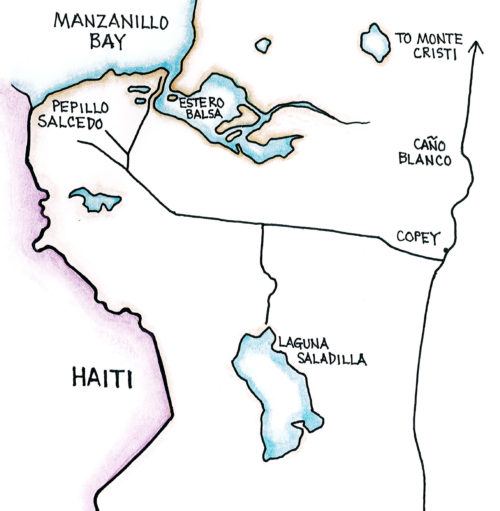
South of Monte Cristi you will find other interesting birding areas, including Estero Balsa and Laguna Saladilla, most of which are protected as part of the large Montecristi National Park. Some of these sites are difficult to enter because of the thick vegetation around the shorelines. Beyond the wetland habitats the landscape is dominated by dry thorn scrub. The threatened Hispaniolan Parakeet is said to come down from the Cordillera Central to nest here, and other species typical of the lowlands should also be expected.


Cayos Siete Hermanos (Map by Dana Gardner)

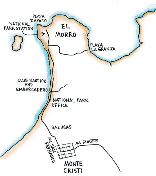
Site A: Salinas – The salt pans (salinas), and the dikes around the salt pans, attract a variety of smaller shorebirds. The dikes may be freely walked; look here for Black-necked Stilt, Willet, and a variety of migratory shorebirds. From near the salt ponds you can also look for herons, egrets and other wading birds coming in to roosts in the afternoon. Of particular note are the White Ibis and the Roseate Spoonbills.

Site B: Playa de la Granja – Drive or walk to Playa de la Granja. Follow Avenida San Fernando past the embarcadero and the Hostal San Fernando; look for an unmarked dirt trail just past the hostal. The road crosses the peninsula behind El Morro through low scrub forest to arrive at the mangrove, sea grape and scrub associated with this beach. Explore along the beach as well as the many small trails in the scrub. An interesting alternative to exploring this area on foot is to hire a boat and guide at the Club Nautico (just before the low bridge) or the embarcadero (just after the low bridge) on the way out to El Morro, and go through the mangroves on a small river.

The remaining sites are south of Monte Cristi along the Carretera Dajabón and are part of the Montecristi National Park. To reach these sites return through town on the Calle Duarte until you reach the prominent corner at Avenida Mella and turn south.

Monte Cristi and Saladilla (Map by Dana Gardner)

Site C: Marigó Wetlands – Leaving central Monte Cristi and heading south, in 2.7 km (1.7 miles) you will cross the Río Yaqui on an old bridge. Just 2.4 km (1.5 miles) further you will encounter the Marigó wetlands. Look for a narrow dirt or mud track on the right that is marked by a small cement block building. You may walk into the wetlands and salt flats.

Site D: La Mina – Continuing south on the Carretera Dajabón you will now be on a long, flat straightaway. Some 13 km (8.1 miles) from central Monte Cristi you will pass through the town of Nueva Judea. Less than 1.6 km (1 mile) beyond the town look for another narrow mud track on the right which is marked by a small concrete building. This is known as the “carretera La Mina” and can be walked as far as a small beach several kilometers distant.

Site E: Caño Blanco – As you continue south, Caño Blanco is a large lagoon that is reached 14.5 km (9 miles) from Monte Cristi. You may scan the lagoon from the road, or you may drive to the south end of the lagoon (about 0.8 or 0.5 miles further) to find a small access road that is marked by a concrete ruin. This road may be walked to the back side of Caño Blanco and beyond, including the area of the Laguna de Nelson which is known for its waterfowl numbers, but is also densely packed with red mangroves.

Site F: Laguna Saladilla – About 20.1 km (12.5 miles) south of Monte Cristi lies the town of Copey, and just beyond is the major crossroads of the Cruz de Manzanillo. Turning right (west) here will take you to the port town of Pepillo Salcedo (generally called Manzanillo), which lies on Manzanillo Bay. You will pass a military checkpoint; then, only 3.7 km (2.3 miles) from the crossroads, look on the left for a small lane just after an abandoned house. This lane will lead you to the margins of Laguna Saladilla. One of the local fishermen will gladly take you out on their boat to explore the lagoon for a small fee.

Site F: Estero Balsa – After traveling 6.4 km (4 miles) from the Cruz de Manzanillo on alternately paved and unpaved road through grazing lands and thorn scrub, on the outskirts of Manzanillo you will bear right at a prominent cemetery that lies on your right. Just beyond this fork is another signed fork; bear right again to reach the Estero Balsa. This leads to another nice wetlands ringed by mangroves. Backtracking to the last fork, you may take the left fork past the banana operations and down to the port where there is a small beach, another small wetland, and a cafeteria.

Target Species: West Indian Whistling- Duck, White- cheeked Pintail, Masked Duck, American Flamingo, Least Bittern, Little Blue Heron, Tricolored Heron, Reddish Egret, White Ibis, Roseate Spoonbill, Clapper Rail, Caribbean Coot, Black- bellied Plover, Snowy Plover, Semipalmated Plover, Northern Jacana, Great Black- backed Gull, Bank Swallow, Cave Swallow

Monte Cristi can be reached by taking Ave. John F. Kennedy in Santo Domingo to the Autopista Duarte and heading north. This is the main north-south highway in the country, and you will pass by Bonao, La Vega, and Santiago. After reaching Santiago, follow the highway signs to Monte Cristi on the Carretera Duarte (the extension of the Autopista Duarte). The drive should take about four and a half hours.

Once in Monte Cristi, you will be on Calle Duarte. This street will take you through the city center. But to reach the better hotels, restaurants and some nearby birding areas, you will want to continue straight ahead on Duarte, passing a prominent intersection with both Shell and Esso stations, and past a city park on your left with a prominent (and interesting) clock tower. Just after this park, and at a traffic light (which may or not be functioning), is Avenida San Fernando. Turn to the right here and head towards the coast. In less than 3 km you will cross through some salt pans, over a low bridge, and past a left hand turn to Playa Juan de Bolaños where a number of tourist accommodations are found. Straight ahead, and on the beach, is the prominent Hotel Montechico where the road turns eastward. Just past the hotel, and on the left is the national park office; on the right and just over a low bridge is the entrance to the embarcadero. Continuing another 2 km on this road will take you to Morro Beach.

Monte Cristi and Saladilla

Dominican Republic Sites

Constanza and Valle Nuevo

Ebano Verde Reserve

Hatillo

Jarabacoa with Armando Bermúdez and José del Carmen Ramírez National Parks

La Joya de San Francisco

Loma Quita Espuela

Pico Diego de Ocampo, Santiago

Bávaro

Cumayasa

Del Este National Park: Boca de Yuma

Del Este National Park: Guaraguao

Del Este National Park: Padre Nuestro Trail

Del Este National Park: Saona Island

Ecological Foundation Trail, Punta Cana

Limón Lagoon

Los Haitises National Park: Caño Hondo

Los Haitises National Park: Los Limones

Monte Plata

Aguacate and Zapotén

Cabo Rojo and Pedernales

Cabral Lagoon

Cachote, Eastern Bahoruco

Jimaní

Lake Enriquillo

Loma Charco Azul

Oviedo Lagoon, Jaragua National Park

Puerto Alejandro and Tortuguero

Rabo de Gato and Puerto Escondido

Los Arroyos, Sierra de Bahoruco National Park

Cayos Siete Hermanos

El Limón, Samaná

Estero Hondo

Loma Guaconejo

Loma Isabel de Torres, Puerto Plata

Monte Cristi and Saladilla

Nalga de Maco National Park, Río Limpio

Samaná

Las Salinas de Baní

Mirador del Norte Park

National Botanical Garden

Ozama Wetlands

Partners in the Dominican Republic

  • Grupo Acción Ecológica
  • La Sociedad Ornitológica de la Hispaniola (SOH)
  • National Aviary

With special thanks to our partners at the Ruta Barrancoli

Ruta Barrancoli logo


Dominican Republic Tour Operators

  • Cúa Birding
  • Explora Ecotour
  • Miguel A. Landestoy T., Independent Guide
  • Tody Tours
  • Wildside Nature Tours

Bird Checklists

Click here to download a pamphlet-sized year-round checklist for Dominican Republic.

Recommended Field Guides

Birds of the Dominican Republic and Haiti by Steven Latta, Christopher Rimmer, Allan Keith, James Wiley, Herbert A. Raffaele, Kent McFarland, and Eladio Fernandez

Aves de la República Dominicana y Haití by Steven Latta, Christopher Rimmer, Allan Keith, James Wiley, Herbert A. Raffaele, Kent McFarland, and Eladio Fernandez

Ruta Barrancolí: A Bird-finding Guide to the Dominican Republic by Steven C. Latta and Kate J. Wallace

Birds of the West Indies by Herbert Raffaele, James Wiley, Orlando Garrido, Allan Keith, and Janis Raffaele

Want to know how you can be involved?

Do you know of a place that should be part of the Caribbean Birding Trail? Are you the owner of a lodge or hotel and want to attract eco-tourists? Are you a guide interested in the birdwatching market? Then, get involved with our project!

Get Involved

The Latest from BirdsCaribbean.org

Twitter
Birds Caribbean
Birds Caribbean
@BirdsCaribbean

Just published in the #JournalOfCaribbeanOrnithology 🗞 (JCO) - understanding susceptibility to 🔬 #avian #malaria in Bananaquits. Learn more about this fascinating study here: bit.ly/JCO-Bananaqui… 📸 Carlos H Almeida #peerreview #openaccess #scicomm #Caribbean pic.twitter.com/BUBT…

reply retweet favorite
5:02 pm · March 24, 2023
Twitter
Birds Caribbean
Birds Caribbean
@BirdsCaribbean

The Smooth-billed #Ani is a bizarre looking #bird 🤨, with its oversized, strangely shaped bill and long tail! Anis are almost always seen in groups and do almost everything together, even incubating #eggs and raising offspring. 📸Russell Campbell ℹ️bit.ly/PhotoContest2… pic.twitter.com/zcdD…

reply retweet favorite
6:01 pm · March 23, 2023
Twitter
Birds Caribbean
Birds Caribbean
@BirdsCaribbean

Happy #WorldWaterDay💧 Just like us #birds need water. Sadly, many of their sources are #threatened by #development #pollution & #climatechange But together we can #BeTheChange we want to see & make water conservation a part of everyday life. ✨ ➡️ bit.ly/JA-Backyard-B… pic.twitter.com/xqM2…

reply retweet favorite
3:12 pm · March 22, 2023
Twitter
Birds Caribbean
Birds Caribbean
@BirdsCaribbean

Happy #InternationalDayOfForests 🌳 We're celebrating 🎉 by featuring the Bicknell’s Thrush 🤎 —a shy, subtle #bird that depends on #forests year-round. Both in the US, where they breed, & in the #Caribbean 🏝 where they migrate to for the winter. ℹ️ birdscaribbean.org/2… pic.twitter.com/eN6N…

reply retweet favorite
4:30 pm · March 21, 2023
Twitter
Birds Caribbean
Birds Caribbean
@BirdsCaribbean

Today is #WorldSparrowDay✨We are particularly excited about this celebratory day because we just can’t resist the cuteness 😊 of these little #birds- like the Grasshopper Sparrow!⁠ Learn more here: youtu.be/7M9FYsM2sxU

reply retweet favorite
7:17 pm · March 20, 2023

Our Site

  • Home
  • About the CBT
  • Countries
  • Tours
  • Guides
  • Get Involved
  • Contact

Search

Follow

Sign up for our Mailing List

Copyright © 2011–2023 Caribbean Birding Trail. A project of BirdsCaribbean.