Caribbean Birding Trail

Know the Caribbean, Bird by Bird

Donate
  • About the CBT
    • Interpretive Guide Training
  • Countries
    • Countries A-I
      • Anguilla
        • Cove Pond
        • Dog Island
        • East End Pond
        • Forest Bay Pond
        • Katouche Canyon
        • Long Pond
        • Meads Bay Pond
        • Merrywing Pond System
        • Prickly Pear Cays
        • Road Salt Pond
        • Scrub Island
        • Sombrero
        • West End By-the-Sea Ponds
        • West End Pond
      • Antigua and Barbuda
        • Bethesda Dam
        • Christian Valley
        • Codrington Lagoon
        • McKinnon’s Salt Pond
        • Two Foot Bay National Park
      • Aruba
        • Spaans Lagoon
      • Bahamas
        • Abaco
        • Andros
        • Cat Island
        • Crooked Island and Acklins
        • Eleuthera
        • Exumas
        • Grand Bahama
        • Great Inagua
        • Long Island
        • Mayaguana
        • New Providence
        • San Salvador
      • Barbados
      • Bonaire
        • Dos Pos IBA
        • Gotomeer
      • British Virgin Islands
        • Josiahs Bay Salt Pond
        • Sandy Cay
      • Cuba
        • Guanahacabibes
        • Humboldt National Park
        • Mensura-Piloto National Park
        • Viñales
        • Zapata Swamp
      • Curaçao
        • Christoffel National Park
        • Salt Pans of Jan Thiel
      • Dominica
      • Dominican Republic
        • Central Mountain Range
          • Constanza and Valle Nuevo
          • Ebano Verde Reserve
          • Hatillo
          • Jarabacoa with Armando Bermúdez and José del Carmen Ramírez National Parks
          • La Joya de San Francisco
          • Loma Quita Espuela
          • Pico Diego de Ocampo, Santiago
        • Southeast
          • Bávaro
          • Cumayasa
          • Del Este National Park
            • Del Este National Park: Boca de Yuma
            • Del Este National Park: Guaraguao
            • Del Este National Park: Padre Nuestro Trail
            • Del Este National Park: Saona Island
          • Ecological Foundation Trail, Punta Cana
          • Limón Lagoon
          • Los Haitises National Park
            • Los Haitises National Park: Caño Hondo
            • Los Haitises National Park: Los Limones
          • Monte Plata
        • Southwest
          • Aguacate and Zapotén
          • Cabo Rojo and Pedernales
          • Cabral Lagoon
          • Cachote, Eastern Bahoruco
          • Jimaní
          • Lake Enriquillo
          • Loma Charco Azul
          • Oviedo Lagoon, Jaragua National Park
          • Puerto Alejandro and Tortuguero
          • Rabo de Gato and Puerto Escondido
          • Sierra de Bahoruco National Park
            • Los Arroyos, Sierra de Bahoruco National Park
        • North Coast
          • Cayos Siete Hermanos
          • El Choco National Park, Cabarete
          • El Limón, Samaná
          • Estero Hondo
          • Loma Guaconejo
          • Loma Isabel de Torres, Puerto Plata
          • Monte Cristi and Saladilla
          • Nalga de Maco National Park, Río Limpio
          • Samaná
        • Around Santo Domingo
          • Las Salinas de Baní
          • Mirador del Norte Park
          • National Botanical Garden
          • Ozama Wetlands
      • Grenada
        • Antoine Lake
        • Beausejour/Grenville Vale
        • Diamond Rock
        • Grand Etang National Park
        • Levera National Park
        • Mt. Hartman National Park
        • Telescope Pond
        • Woburn Bay MPA
      • Guadeloupe
        • Mountain Road
        • Pointe des Chateaux
    • Countries J-Z
      • Jamaica
        • Ahhh…Ras Natango Gallery and Garden
        • Barbecue Bottom Road
        • Black River Great Morass
        • Cockpit Country
        • Ecclesdown Road
        • Flagstaff
        • Green Hills Field Station
        • Hardwar Gap
        • Hope Gardens
        • Portland Bight Protected Area
        • Stewart Town
      • Martinique
        • Rocher du Diamant
      • Montserrat
      • Puerto Rico
        • Camuy Coastal Area
        • Culebra National Wildlife Refuge
        • Laguna Cartagena National Wildlife Refuge
      • Sint Eustatius
        • Pilot Hill
        • Quill/Boven National Park
        • Zeelandia Beach
      • St. Lucia
      • Sint Maarten
        • Great Salt Pond
        • Little Bay Pond
      • St. Martin
        • Amuseum Naturalis at The Old House
        • Étang Cimetière de Grand Case
        • Étang de la Barrière
        • Pic Paradis
      • St. Vincent and the Grenadines
        • Grenadines
          • Bird Sanctuary
          • Mustique Lagoon
          • Mustique Ponds Walk
        • Saint Vincent
          • Richmond Beach
      • Trinidad and Tobago
        • Tobago
          • Kilgwyn Swamp
          • Little Tobago
        • Trinidad
          • Asa Wright Nature Centre
          • Brasso Seco Paria Village
      • Turks and Caicos
        • Grand Turk
        • Middle Caicos
        • North Caicos
        • Providenciales
        • Salt Cay
        • South Caicos
  • Tours
  • Guides
  • Get Involved
  • Contact Us

You are here: Home / Dominican Republic / Southeast / Ecological Foundation Trail, Punta Cana

Ecological Foundation Trail, Punta Cana

  • About
  • The Birds
  • How to Get There

Punta Cana, probably the most well-known resort area in the country, is at the easternmost tip of the Dominican Republic. The habitat of this area is comprised mostly of lowland moist forests, coastal shrub-land, pastureland and urban areas, as well as mangroves, lagoons, and beaches. Punta Cana is the most highly visited Caribbean destination resort. Nevertheless, over 100 different species of birds have been identified in Punta Cana during the winter migration season, and opportunities to learn and appreciate many of Hispaniola’s interesting bird species are available in the Punta Cana area. Our target species for Punta Cana include many species endemic to the island or to the Caribbean region, such as Hispaniolan Parrot, Hispaniolan Lizard-Cuckoo

Antillean Nighthawk, Antillean Palm-Swift, Broad-billed Tody, Palmchat, Bananaquit, Black-crowned Palm-Tanager, and Hispaniolan Oriole, as well as several hard-to-find introduced species such as Eurasian Collared Dove and Pearly-eyed Thrasher. In addition, you may be able to see reintroduced individuals of the islands most endangered bird, the Ridgway’s Hawk.

Since its 1969 inception Puntacana Resort and Club has been recognized as a pioneer of sustainable development and tourism practices. In 1994 the developers founded The Puntacana Ecological Foundation to protect and maintain the health of the coastal ecosystem. The Ecological Foundation was formed with the donation of more than 600 hec of land to be set aside for scientific investigation and conservation. The Foundation also developed the Center for Sustainability and Biodiversity of Puntacana with the help of international collaborators.

Birding Areas

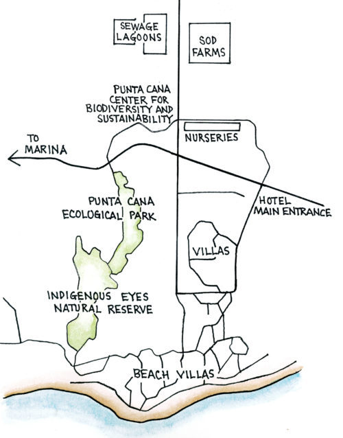
There are a variety of good birding areas at Puntacana Resort and Club that are centered on the Puntacana Ecological Foundation. Behind the Center for Sustainability are a system of short trails that wind through a variety of gardens, tropical fruit orchards, and scrub forest. A longer, more developed trail is known as the Indian Eyes Trail. Access to this circular trail is made through the hotel which is across the street from the Ecological Foundation; you should call ahead to the Foundation if you would like to access this trail but are not a guest of the hotel. The Foundation may also be able to provide a guide.

Closer to the hotel also is the marina which is worth checking for seabirds, but also for Yellow-crowned Night-herons at night. Two additional sites that are well worth a look lie at the end of an access road behind the Ecological Foundation. Within walking distance are a sod farm (on the right) and a series of sewage lagoons (on the left). The sod farm has turned up a number of rarities, including Purple Sandpiper and American Golden-Plover, as well as other shorebirds. The lagoons attract a wide variety of waterfowl, shorebirds, and waders, including both Yellow-crowned and Black-crowned night-herons.

Target Species

Magnificent Frigatebird, Great Blue Heron, Snowy Egret, Tricolored Heron, Reddish Egret, Black- crowned Night- heron, Yellow- crowned Night- heron, Reddish Egret, Ridgway’s Hawk, Wilson’s Plover, Black- necked Stilt, Ruddy Turnstone, Laughing Gull, Royal Tern, Eurasian Collared Dove, Hispaniolan Parrot, Hispaniolan Lizard- Cuckoo, Antillean Nighthawk, Antillean Palm- Swift, Antillean Mango, Vervain Hummingbird, Broad- billed Tody, Hispaniolan Woodpecker, Pearly- eyed Thrasher, Palmchat, Bananaquit, Black- crowned Palm- Tanager, Hispaniolan Oriole

Most visitors to the area will arrive at the Punta Cana International Airport. Visitors driving from Santo Domingo will head east on the main coastal highway to San Pedro de Macorís, then continue on to La Romana passing over the Río Cumayasa bridge (Site D24). About 10.9 km (6.8 miles) east of the Río Cumayasa bridge turn right at a stop light following signs for Casa de Campo and Higuey. Cross the Río Chavón, pass straight through a rotary, until arriving in 19.3 km (12 miles) at a prominent fork in the road (the “La Romana-Bayahibe fork”). Continue on towards Higuey; 15.4 km (9.6 miles) later you will turn north (left) on Route 4 (turning right will take you to Boca de Yuma, Site D28). From here you will travel through sugar cane and grazing pastures for 14.8 km (9.2 miles) where you will arrive at a stoplight.

Turn left at this light following signs for Bávaro, Punta Cana, and the Basilica of the Virgin of Altagracia. At another traffic light a short 1.0 km (0.6 mile) further on, you will rejoin Route 3 (with Route 4 turning left and continuing on towards El Seibo), and you will pass the oppressive Basilica. At the second light beyond the Basilica, follow signs towards Bávaro and Punta Cana and turn right. You will soon leave Higuey headed for Otra Banda which is reached in about 8.0 km (5.0 miles). At the light in Otra Banda turn right, and continue on 24.1 km (15 miles) to the town of Veron. Veron appears as more of a commercial strip, but food, gas and other services are found here which are not readily available in Punta Cana.

From Veron, you will drive east another 3.2 km (2 miles) before encountering a metal arch across the road with a Shell station on the right. Turning left here would take you towards Bávaro on Route 105; you will instead want to continue straight on Route 106 towards Punta Cana. After 5.0 km (3.1 miles) you will need to turn right on a divided highway; this is not signed but there is no other option. Continue straight through two rotaries; at the third rotary bear right to the Puntacana Resort and Club. In about 2.4 km (1.5 miles) you will go straight through yet another rotary, and in 3.5 km (2.2 miles) you should see the entrance for the Fundación Ecológico (Puntacana Ecological Foundation).

Ecological Foundation Trail, Punta Cana (Map by Dana Gardner)


  • Reserve hours: open daily from sunup to sundown
  • Entrance fee: none; open to members and guests, or by special arrangement
  • Telephone: telephone 809-959-9221
  • E-mail: [email protected]
  • Website: www.puntacana.org

Ecological Foundation Trail, Punta Cana

Dominican Republic Sites

Constanza and Valle Nuevo

Ebano Verde Reserve

Hatillo

Jarabacoa with Armando Bermúdez and José del Carmen Ramírez National Parks

La Joya de San Francisco

Loma Quita Espuela

Pico Diego de Ocampo, Santiago

Bávaro

Cumayasa

Del Este National Park: Boca de Yuma

Del Este National Park: Guaraguao

Del Este National Park: Padre Nuestro Trail

Del Este National Park: Saona Island

Ecological Foundation Trail, Punta Cana

Limón Lagoon

Los Haitises National Park: Caño Hondo

Los Haitises National Park: Los Limones

Monte Plata

Aguacate and Zapotén

Cabo Rojo and Pedernales

Cabral Lagoon

Cachote, Eastern Bahoruco

Jimaní

Lake Enriquillo

Loma Charco Azul

Oviedo Lagoon, Jaragua National Park

Puerto Alejandro and Tortuguero

Rabo de Gato and Puerto Escondido

Los Arroyos, Sierra de Bahoruco National Park

Cayos Siete Hermanos

El Limón, Samaná

Estero Hondo

Loma Guaconejo

Loma Isabel de Torres, Puerto Plata

Monte Cristi and Saladilla

Nalga de Maco National Park, Río Limpio

Samaná

Las Salinas de Baní

Mirador del Norte Park

National Botanical Garden

Ozama Wetlands

Partners in the Dominican Republic

  • Grupo Acción Ecológica
  • La Sociedad Ornitológica de la Hispaniola (SOH)
  • National Aviary

With special thanks to our partners at the Ruta Barrancoli

Ruta Barrancoli logo


Dominican Republic Tour Operators

  • Cúa Birding
  • Explora Ecotour
  • Miguel A. Landestoy T., Independent Guide
  • Tody Tours
  • Wildside Nature Tours

Bird Checklists

Click here to download a pamphlet-sized year-round checklist for Dominican Republic.

Recommended Field Guides

Birds of the Dominican Republic and Haiti by Steven Latta, Christopher Rimmer, Allan Keith, James Wiley, Herbert A. Raffaele, Kent McFarland, and Eladio Fernandez

Aves de la República Dominicana y Haití by Steven Latta, Christopher Rimmer, Allan Keith, James Wiley, Herbert A. Raffaele, Kent McFarland, and Eladio Fernandez

Ruta Barrancolí: A Bird-finding Guide to the Dominican Republic by Steven C. Latta and Kate J. Wallace

Birds of the West Indies by Herbert Raffaele, James Wiley, Orlando Garrido, Allan Keith, and Janis Raffaele

Want to know how you can be involved?

Do you know of a place that should be part of the Caribbean Birding Trail? Are you the owner of a lodge or hotel and want to attract eco-tourists? Are you a guide interested in the birdwatching market? Then, get involved with our project!

Get Involved

The Latest from BirdsCaribbean.org

Twitter
Birds Caribbean
Birds Caribbean
@BirdsCaribbean

Just published in the #JournalOfCaribbeanOrnithology 🗞 (JCO) - understanding susceptibility to 🔬 #avian #malaria in Bananaquits. Learn more about this fascinating study here: bit.ly/JCO-Bananaqui… 📸 Carlos H Almeida #peerreview #openaccess #scicomm #Caribbean pic.twitter.com/BUBT…

reply retweet favorite
5:02 pm · March 24, 2023
Twitter
Birds Caribbean
Birds Caribbean
@BirdsCaribbean

The Smooth-billed #Ani is a bizarre looking #bird 🤨, with its oversized, strangely shaped bill and long tail! Anis are almost always seen in groups and do almost everything together, even incubating #eggs and raising offspring. 📸Russell Campbell ℹ️bit.ly/PhotoContest2… pic.twitter.com/zcdD…

reply retweet favorite
6:01 pm · March 23, 2023
Twitter
Birds Caribbean
Birds Caribbean
@BirdsCaribbean

Happy #WorldWaterDay💧 Just like us #birds need water. Sadly, many of their sources are #threatened by #development #pollution & #climatechange But together we can #BeTheChange we want to see & make water conservation a part of everyday life. ✨ ➡️ bit.ly/JA-Backyard-B… pic.twitter.com/xqM2…

reply retweet favorite
3:12 pm · March 22, 2023
Twitter
Birds Caribbean
Birds Caribbean
@BirdsCaribbean

Happy #InternationalDayOfForests 🌳 We're celebrating 🎉 by featuring the Bicknell’s Thrush 🤎 —a shy, subtle #bird that depends on #forests year-round. Both in the US, where they breed, & in the #Caribbean 🏝 where they migrate to for the winter. ℹ️ birdscaribbean.org/2… pic.twitter.com/eN6N…

reply retweet favorite
4:30 pm · March 21, 2023
Twitter
Birds Caribbean
Birds Caribbean
@BirdsCaribbean

Today is #WorldSparrowDay✨We are particularly excited about this celebratory day because we just can’t resist the cuteness 😊 of these little #birds- like the Grasshopper Sparrow!⁠ Learn more here: youtu.be/7M9FYsM2sxU

reply retweet favorite
7:17 pm · March 20, 2023

Our Site

  • Home
  • About the CBT
  • Countries
  • Tours
  • Guides
  • Get Involved
  • Contact

Search

Follow

Sign up for our Mailing List

Copyright © 2011–2023 Caribbean Birding Trail. A project of BirdsCaribbean.