Caribbean Birding Trail

Know the Caribbean, Bird by Bird

Donate
  • About the CBT
    • Interpretive Guide Training
  • Countries
    • Countries A-I
      • Anguilla
        • Cove Pond
        • Dog Island
        • East End Pond
        • Forest Bay Pond
        • Katouche Canyon
        • Long Pond
        • Meads Bay Pond
        • Merrywing Pond System
        • Prickly Pear Cays
        • Road Salt Pond
        • Scrub Island
        • Sombrero
        • West End By-the-Sea Ponds
        • West End Pond
      • Antigua and Barbuda
        • Bethesda Dam
        • Christian Valley
        • Codrington Lagoon
        • McKinnon’s Salt Pond
        • Two Foot Bay National Park
      • Aruba
        • Spaans Lagoon
      • Bahamas
        • Abaco
        • Andros
        • Cat Island
        • Crooked Island and Acklins
        • Eleuthera
        • Exumas
        • Grand Bahama
        • Great Inagua
        • Long Island
        • Mayaguana
        • New Providence
        • San Salvador
      • Barbados
      • Bonaire
        • Dos Pos IBA
        • Gotomeer
      • British Virgin Islands
        • Josiahs Bay Salt Pond
        • Sandy Cay
      • Cuba
        • Guanahacabibes
        • Humboldt National Park
        • Mensura-Piloto National Park
        • Viñales
        • Zapata Swamp
      • Curaçao
        • Christoffel National Park
        • Salt Pans of Jan Thiel
      • Dominica
      • Dominican Republic
        • Central Mountain Range
          • Constanza and Valle Nuevo
          • Ebano Verde Reserve
          • Hatillo
          • Jarabacoa with Armando Bermúdez and José del Carmen Ramírez National Parks
          • La Joya de San Francisco
          • Loma Quita Espuela
          • Pico Diego de Ocampo, Santiago
        • Southeast
          • Bávaro
          • Cumayasa
          • Del Este National Park
            • Del Este National Park: Boca de Yuma
            • Del Este National Park: Guaraguao
            • Del Este National Park: Padre Nuestro Trail
            • Del Este National Park: Saona Island
          • Ecological Foundation Trail, Punta Cana
          • Limón Lagoon
          • Los Haitises National Park
            • Los Haitises National Park: Caño Hondo
            • Los Haitises National Park: Los Limones
          • Monte Plata
        • Southwest
          • Aguacate and Zapotén
          • Cabo Rojo and Pedernales
          • Cabral Lagoon
          • Cachote, Eastern Bahoruco
          • Jimaní
          • Lake Enriquillo
          • Loma Charco Azul
          • Oviedo Lagoon, Jaragua National Park
          • Puerto Alejandro and Tortuguero
          • Rabo de Gato and Puerto Escondido
          • Sierra de Bahoruco National Park
            • Los Arroyos, Sierra de Bahoruco National Park
        • North Coast
          • Cayos Siete Hermanos
          • El Choco National Park, Cabarete
          • El Limón, Samaná
          • Estero Hondo
          • Loma Guaconejo
          • Loma Isabel de Torres, Puerto Plata
          • Monte Cristi and Saladilla
          • Nalga de Maco National Park, Río Limpio
          • Samaná
        • Around Santo Domingo
          • Las Salinas de Baní
          • Mirador del Norte Park
          • National Botanical Garden
          • Ozama Wetlands
      • Grenada
        • Antoine Lake
        • Beausejour/Grenville Vale
        • Diamond Rock
        • Grand Etang National Park
        • Levera National Park
        • Mt. Hartman National Park
        • Telescope Pond
        • Woburn Bay MPA
      • Guadeloupe
        • Mountain Road
        • Pointe des Chateaux
    • Countries J-Z
      • Jamaica
        • Ahhh…Ras Natango Gallery and Garden
        • Barbecue Bottom Road
        • Black River Great Morass
        • Cockpit Country
        • Ecclesdown Road
        • Flagstaff
        • Green Hills Field Station
        • Hardwar Gap
        • Hope Gardens
        • Portland Bight Protected Area
        • Stewart Town
      • Martinique
        • Rocher du Diamant
      • Montserrat
      • Puerto Rico
        • Camuy Coastal Area
        • Culebra National Wildlife Refuge
        • Laguna Cartagena National Wildlife Refuge
      • Sint Eustatius
        • Pilot Hill
        • Quill/Boven National Park
        • Zeelandia Beach
      • St. Lucia
      • Sint Maarten
        • Great Salt Pond
        • Little Bay Pond
      • St. Martin
        • Amuseum Naturalis at The Old House
        • Étang Cimetière de Grand Case
        • Étang de la Barrière
        • Pic Paradis
      • St. Vincent and the Grenadines
        • Grenadines
          • Bird Sanctuary
          • Mustique Lagoon
          • Mustique Ponds Walk
        • Saint Vincent
          • Richmond Beach
      • Trinidad and Tobago
        • Tobago
          • Kilgwyn Swamp
          • Little Tobago
        • Trinidad
          • Asa Wright Nature Centre
          • Brasso Seco Paria Village
      • Turks and Caicos
        • Grand Turk
        • Middle Caicos
        • North Caicos
        • Providenciales
        • Salt Cay
        • South Caicos
  • Tours
  • Guides
  • Get Involved
  • Contact Us

You are here: Home / Cayman Islands / Mastic Trail

Mastic Trail

  • About Mastic Trail
  • The Birds
  • How to Get There
  • Where to Stay
  • Tour Operators and Guides

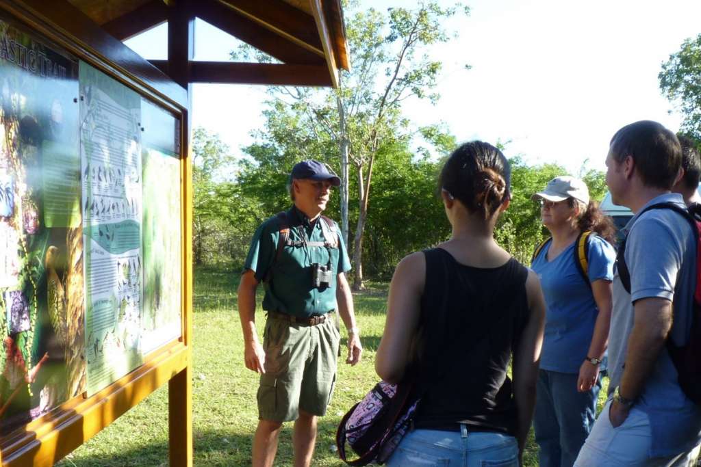
Grand Cayman’s Mastic Reserve protects a 840-acre portion of the largest contiguous section of old growth dry forest left on the island and can be explored via the 2.3-mile (one-way) out-and-back Mastic Trail. The southern trailhead is the traditional starting point for hikers. National Trust facilities here include a parking area, interpretive signage with information on wildlife, and a composting toilet.

Nature guide Stuart Mailer briefs a group of visitors at the southern trailhead
Nature guide Stuart Mailer briefs a group of visitors at the southern trailhead (Photo by M. Christine Rose-Smyth)

A short distance from the trailhead the path enters a wetland forest. The lowest-lying area of the wetland is traversed by an extensive boardwalk under a shady canopy of Black Mangroves. This is followed by a section of seasonally flooded forest, a mix of towering tropical hardwoods such as Bitter Plum and Mahogany trees, and magnificent Royal Palms. The trail continues through an abandoned Mango orchard, followed by a raised rocky area known as the Fissure Zone, which features deep linear fractures in the bedrock.

A hiker points out a genet of endemic Wild Banana Orchids growing high on the trunk of a Mahogany
A hiker points out a genet of endemic Wild Banana Orchids growing high on the trunk of a Mahogany (Photo by Stuart Mailer)

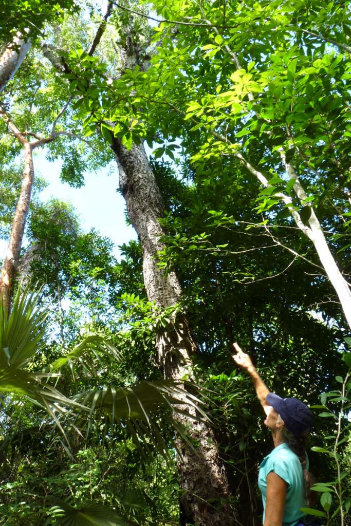
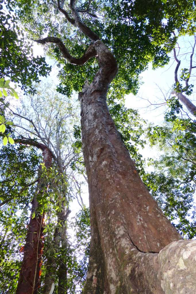
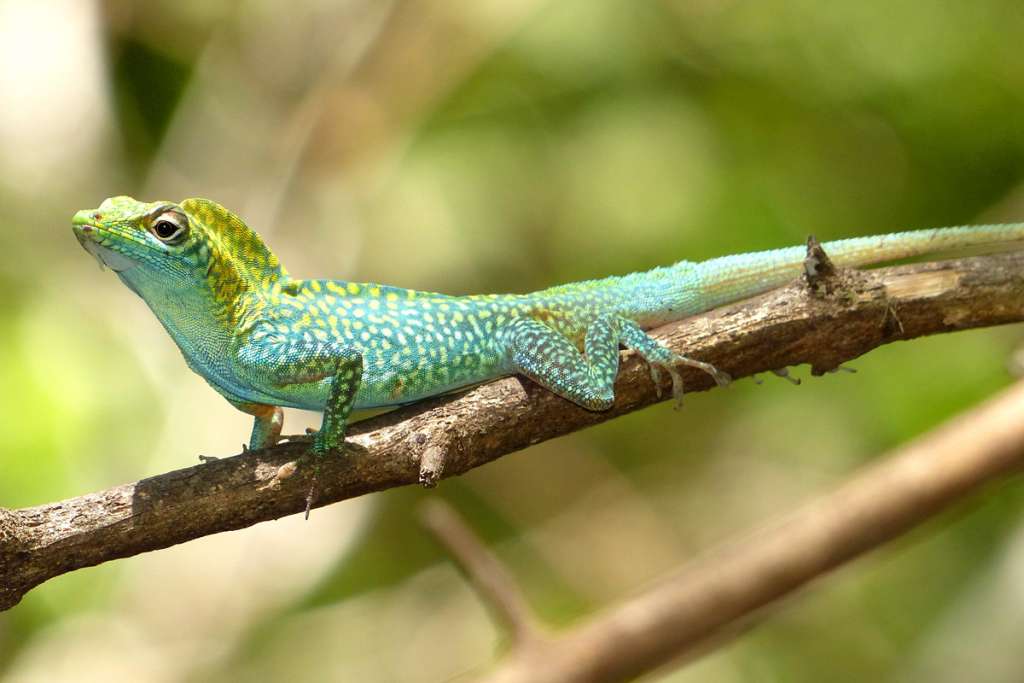
After passing through another section of low-lying forest dominated by Royal Palms and Mahoganies, the trail rises onto jagged, karstic limestone, with no significant soil. This is the start of the ancient Old Growth Forest. The combination of remoteness and lack of soil have protected the forest from significant human disturbance. The trail gradually climbs and, as the elevation increases, so does the height of the tree canopy. Near the halfway point of the trail, hikers traditionally take a rest break beneath a towering Yellow Mastic Tree.

An ancient Yellow Mastic close to the halfway point of the trail. This species, for which the Reserve and Trail are named, was once an important source of timber for Cayman’s historic ship-building industry
An ancient Yellow Mastic close to the halfway point of the trail. This species, for which the Reserve and Trail are named, was once an important source of timber for Cayman’s historic ship-building industry (Photo by Stuart Mailer)

The trail continues through the ancient forest until reaching the northern edge of the rugged karstic platform, where a sharp drop represents an ancient shoreline, created approximately 125,000 years ago during the last major interglacial warming, when sea levels around the world were 20 feet above present day levels. From this point the trail continues north through an area that was historically cleared for agriculture as the ground is comparatively level, and there are significant pockets of soil. The land has however been abandoned for many years and is now covered in secondary forest. As the trail approaches the northern end it passes through several “grass pieces”, tracts of land where Guinea Grass was grown as fodder until a few decades ago. The trail then meanders through overgrown pastureland, before emerging at the northern trailhead next to a small produce farm.

The Cuban Tree Frog, native to all 3 Cayman Islands, is a common sight along the trail
The Cuban Tree Frog, native to all 3 Cayman Islands, is a common sight along the trail (Photo by Stuart Mailer)

Keep in mind that the trail is not a loop, so back-tracking is required unless a vehicle is arranged at each end. Most of the trail is fairly level, but some areas are quite rugged, with numerous trip hazards. Sections of the southern portions can be muddy or flooded following heavy rains. Strong shoes, adequate drinking water and bug spray are all recommended.

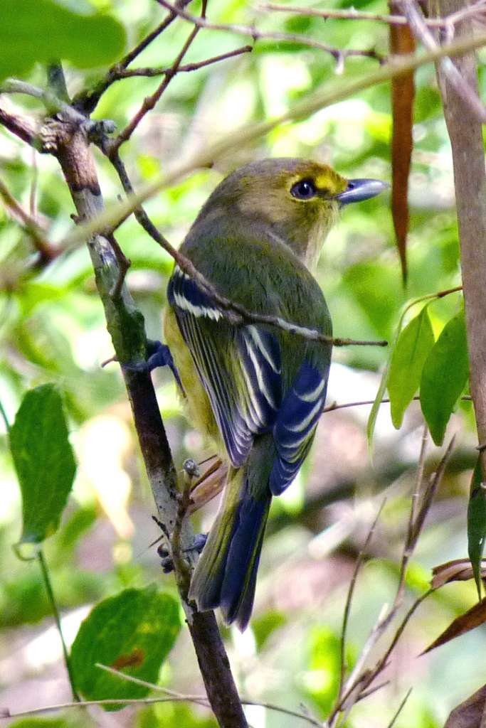
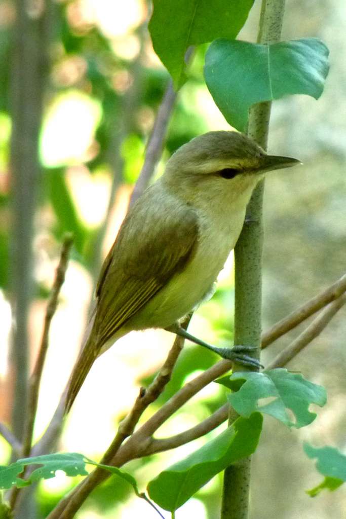
All thirteen woodland birds that are unique to Grand Cayman can be found here. Of these, the Cuban Parrot, Vitelline Warbler, Cuban Bullfinch, and Thick-billed Vireo are also restricted-range species.

Thick-billed Vireo – Usually encountered foraging in pairs in dry forest understory and dense shrub land
Thick-billed Vireo – Usually encountered foraging in pairs in dry forest understory and dense shrub land (Photo by Stuart Mailer)

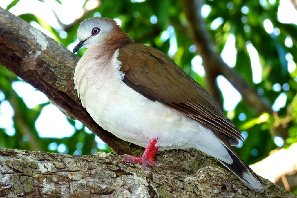
Non-endemic forest birds that are commonly seen include the White-crowned Pigeon, White-winged Dove, Common Ground Dove, Zenaida Dove, Yellow-faced Grassquit, Northern Mockingbird, Yellow Warbler, La Sagra’s Flycatcher, and Smooth-billed Ani.

Caribbean Doves are restricted to the less-developed, western half of Grand Cayman. Generally ground-dwelling, they are often encountered in pairs, walking slowly along the trail, but increasing their pace as visitors approach.
Caribbean Doves are restricted to the less-developed, western half of Grand Cayman. Generally ground-dwelling, they are often encountered in pairs, walking slowly along the trail, but increasing their pace as visitors approach (Photo by Stuart Mailer).

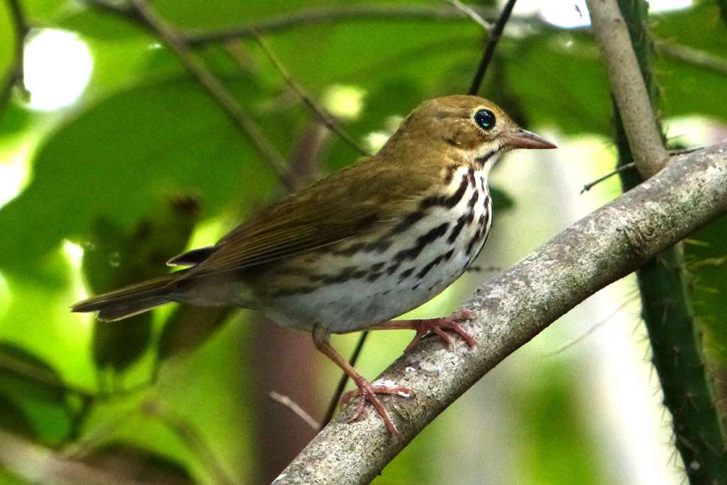
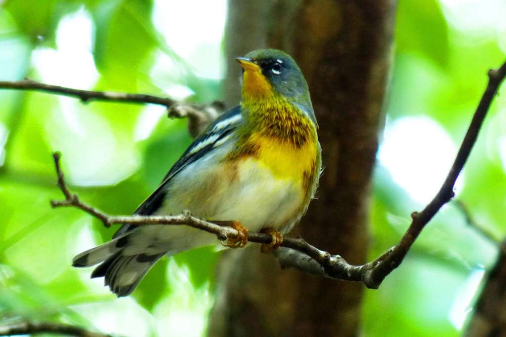
Between early autumn and late spring, the Mastic Trail is also a great location to spot migratory birds. Warbler species that frequently over-winter here include the Ovenbird, Common Yellowthroat, Northern Parula, Black and White Warbler, Yellow-throated Warbler, Black-throated Blue Warbler, Northern Waterthrush, and American Redstart.

Ovenbird – usually seen on, or close to close to ground (Photo by Stuart Mailer)
Northern Parula - A common over-winter migrant forages for insects from high in the canopy almost to the ground
Northern Parula – A common over-winter migrant forages for insects from high in the canopy almost to the ground (Photo by Stuart Mailer)

Other migratory forest birds recorded along the trail include Grey Catbird, Rose-breasted Grosbeak, Yellow-bellied Sapsucker, and we now know that the more secretive Swainson’s Warbler overwinters here as well.

The southern trailhead is about a 25-minute drive from the capital city of George Town, while the northern trailhead is approximately 10 minutes further along. The trail is best accessed by rental car as taxis are expensive. The local buses provide infrequent service that pass approximately ½ mile from each trailhead. Using the bus does have the advantage of allowing an end-to-end hike without the need for backtracking.

The Blue-throated Anole is endemic to Grand Cayman. Male lizards are capable of rapid changes in coloration, leading to their local name of “Chameleon”
The Blue-throated Anole is endemic to Grand Cayman. Male lizards are capable of rapid changes in coloration, leading to their local name of “Chameleon” (Photo by Stuart Mailer).

Accessing the Mastic Trail from any location on the island is less than an hour’s drive, but the most convenient tourist accommodations are in the surrounding districts of North Side (Old Man Bay, Rum Point), East End (Morritt’s Tortuga, Wyndham Reef), and Bodden Town (Turtle Nest Inn).

Yucatan Vireo – Locally known as “Sweet Bridget” after its distinctive song, is found in both Black Mangrove and dry forest
Yucatan Vireo – Locally known as “Sweet Bridget” after its distinctive song, is found in both Black Mangrove and dry forest (Photo by Stuart Mailer)

There are two professional bird guides offering tours on Grand Cayman: Stuart Mailer of Bird-Cayman and Geddes Hislop of Silver Thatch Tours.

Guests are also welcome to walk the trail without a guide, but are advised to familiarize themselves with dangerous plants that may be encountered. Further information is provided on the signage at the southern trailhead, in a guide booklet available from the National Trust offices in George Town, and also usually available at the nearby Botanic Park gift shop.

Mastic Trail

Cayman Islands Sites

  • Mastic Trail
  • Queen Elizabeth II Botanic Park


Cayman Islands Tour Operators

  • Bird-Cayman
  • Silver Thatch Excursions

Recommended Bird Guides

A Photographic Guide to the Birds of the Cayman Islands by Patricia E. Bradley and Yves-Jacques Rey-Millet

Birds of the West Indies by Herbert Raffaele, James Wiley, Orlando Garrido, Allan Keith, and Janis Raffaele

Want to know how you can be involved?

Do you know of a place that should be part of the Caribbean Birding Trail? Are you the owner of a lodge or hotel and want to attract eco-tourists? Are you a guide interested in the birdwatching market? Then, get involved with our project!

Get Involved

The Latest from BirdsCaribbean.org

Twitter
Birds Caribbean
Birds Caribbean
@BirdsCaribbean

Just published in the #JournalOfCaribbeanOrnithology 🗞 (JCO) - understanding susceptibility to 🔬 #avian #malaria in Bananaquits. Learn more about this fascinating study here: bit.ly/JCO-Bananaqui… 📸 Carlos H Almeida #peerreview #openaccess #scicomm #Caribbean pic.twitter.com/BUBT…

reply retweet favorite
5:02 pm · March 24, 2023
Twitter
Birds Caribbean
Birds Caribbean
@BirdsCaribbean

The Smooth-billed #Ani is a bizarre looking #bird 🤨, with its oversized, strangely shaped bill and long tail! Anis are almost always seen in groups and do almost everything together, even incubating #eggs and raising offspring. 📸Russell Campbell ℹ️bit.ly/PhotoContest2… pic.twitter.com/zcdD…

reply retweet favorite
6:01 pm · March 23, 2023
Twitter
Birds Caribbean
Birds Caribbean
@BirdsCaribbean

Happy #WorldWaterDay💧 Just like us #birds need water. Sadly, many of their sources are #threatened by #development #pollution & #climatechange But together we can #BeTheChange we want to see & make water conservation a part of everyday life. ✨ ➡️ bit.ly/JA-Backyard-B… pic.twitter.com/xqM2…

reply retweet favorite
3:12 pm · March 22, 2023
Twitter
Birds Caribbean
Birds Caribbean
@BirdsCaribbean

Happy #InternationalDayOfForests 🌳 We're celebrating 🎉 by featuring the Bicknell’s Thrush 🤎 —a shy, subtle #bird that depends on #forests year-round. Both in the US, where they breed, & in the #Caribbean 🏝 where they migrate to for the winter. ℹ️ birdscaribbean.org/2… pic.twitter.com/eN6N…

reply retweet favorite
4:30 pm · March 21, 2023
Twitter
Birds Caribbean
Birds Caribbean
@BirdsCaribbean

Today is #WorldSparrowDay✨We are particularly excited about this celebratory day because we just can’t resist the cuteness 😊 of these little #birds- like the Grasshopper Sparrow!⁠ Learn more here: youtu.be/7M9FYsM2sxU

reply retweet favorite
7:17 pm · March 20, 2023

Our Site

  • Home
  • About the CBT
  • Countries
  • Tours
  • Guides
  • Get Involved
  • Contact

Search

Follow

Sign up for our Mailing List

Copyright © 2011–2023 Caribbean Birding Trail. A project of BirdsCaribbean.